Resource geoscience
Type of resources
Keywords
Publication year
Topics
-
<div>Tin and tungsten have good potentials for increased demand applications particularly in the electrical and energy storage areas. Similar to other critical metals like Li and Co, Sn and W are essential ingredients for many applications and technologies that are important for a sustainable future. </div><div> </div><div>Granite related hydrothermal mineral systems are the predominant source for Sn and W deposits.Cassiterite, wolframite and scheelite are primary Sn and W ore minerals in nature. The distribution of Sn rich areas around the world is uneven, which may reflects that geochemical heritage is fundamental to form Sn and W deposits. Besides, magmatic differentiation has been considered as another efficient way to enrich Sn in various geological reservoirs. The tectonic setting of Sn and W mineralisation is well understood, with most Sn and W deposits having formed at active margin settings. A comparison between the Tethyan and Andean Sn-W mineral systems confirmed that Sn and W mineral systems can form under thickened continental crust associated with an oceanic crust subduction. The importance of granitoids for the formation of Sn and W mineral systems is well understood. The genetic affinity of causative intrusions can be either S-type, I-type or A-type, but a common feature is that they are reduced (or ilmenite series) and highly evolved (high SiO2 content and high Rb/Sr ratio). Another prominent feature for Sn and W mineral systems is their high concentration of critical metals, including Li, Ce, Ta and In etc. Therefore, Sn and W mineralisation has a close association with other critical metal mineralisation. Overall, the precipitation mechanisms of W (wolframite and scheelite) and Sn (cassiterite) ore minerals from the hydrothermal fluid include (1) fluids mixing, (2) boiling and, (3) water-rock interaction. </div><div><br></div><div>Recent studies have highlighted discrepancies in Sn mineralisation and W mineralisation conditions. Although Sn- and W-associated granites have substantial overlapping characteristics, many of their physico-chemical natures (e.g., aluminum-saturation index (ASI) values, zirconium saturation temperatures and crystal fractionation degrees) are distinctive, suggesting Sn- and W-granites may form under different geological conditions. The difference between Sn mineralisation and W mineralisation is also evident by their contrasting fluid-melt partitioning coefficients. Tungsten strongly partitions into the aqueous fluid and can be transported farther away from the intrusion, but Sn slightly partitions into the silicate melt and can precipitate as magmatic cassiterite or be incorporated into crystallizing micas (which can have >100 ppm Sn). Another area warranting more study is understanding the elemental associations observed in Sn and W mineral systems. It is common to have many other metals in Sn-dominant mineral systems, for example W, Li, Nb, Ta. For W-dominant mineral systems, apart from with Sn, other common associated metals include Mo, Au-Bi and Cu. Nevertheless, the relationship between Sn-W and Cu-Au mineral systems at both the regional/provincial-scale and deposit-scale is an intriguing puzzle, because Sn-W and Cu-Au deposits are generally formed under different geological conditions, though their tectonic setting are similar, i.e., arc-related subduction and continental collision. An emerging field for understanding Sn and W mineral systems is made possible with the development of micro-analytical techniques, e.g., in-situ U-Pb geochronology and O-isotopic analyses on cassiterite and wolframite enable a greater understanding of Sn and W mineralising systems. Since both are the primary ore minerals, U-Pb dating on them can deliver direct age information - an advantage compared with many other commodities types like Cu, Au and Ag. However, unlike those commodities, impactful advances on Sn and W exploration models, techniques, and tools have been deficient in recent years; therefore, more attention and effort is needed to boost Sn and W mineral exploration in the future.</div><div><br></div>This paper was presented to the 2022 Asian Current Research on Fluid Inclusions IX (ACROFI IX) Conference 12-13 December (http://www.csmpg.org.cn/tzgg2017/202210/t20221011_6522628.html)
-
<div>The architecture of the lithosphere controls the distribution of thermal, compositional and rheological interfaces. It therefore plays a fundamental role in modulating key ore-forming processes including the generation, transport, fractionation, and contamination of melts. Recognition of its importance has led to renewed efforts in recent years to incorporate constraints on lithospheric structure into the targeting of prospective regions for mineral exploration. One example is a suggested relationship between the genesis of porphyry copper deposits – known to be associated with evolved, silica-rich magmas – and the thickness of the crust. Here, using a new compilation of spot measurements, we explore the utility of crustal thickness as an exploration tool for porphyry copper deposits.</div> This Abstract was submitted & presented at the 2022 American Geophysical Union (AGU) Fall Meeting 12-16 December (https://www.agu.org/Fall-Meeting-2022)
-
<div>The National Geochemical Survey of Australia (NGSA) is Australia’s only internally consistent, continental-scale geochemical atlas and dataset. The present dataset contains additional mineralogical data obtained on NGSA samples selected from the Barkly-Isa-Georgetown (BIG) region of northeastern Australia for the second partial data release of the Heavy Mineral Map of Australia (HMMA) project. The HMMA project, a collaborative project between Geoscience Australia and Curtin University underpinned by a pilot project establishing its feasibility, is part of the Australian Government-funded Exploring for the Future (EFTF) program.</div><div>One-hundred and eighty eight NGSA sediment samples were selected from the HMMA project within the EFTF’s BIG polygon plus an approximately one-degree buffer. The samples were taken on average from 60 to 80 cm depth in floodplain landforms, dried and sieved to a 75-430 µm grainsize fraction, and the contained heavy minerals (HMs; i.e., those with a specific gravity > 2.9 g/cm3) were separated by dense fluids and mounted on cylindrical epoxy mounts. After polishing and carbon-coating, the mounts were subjected to automated mineralogical analysis on a TESCAN® Integrated Mineral Analyzer (TIMA). Using scanning electron microscopy and backscatter electron imaging integrated with energy dispersive X-ray analysis, the TIMA identified 151 different HMs in the BIG area. The dataset, consisting of over 18 million individual mineral grains, was quality controlled and validated by an expert team. The data released here can be visualised, explored and downloaded using an online, bespoke mineral network analysis (MNA) tool built on a cloud-based platform. Preliminary analysis suggests that copper minerals cuprite and chalcopyrite may be indicative of base-metal/copper mineralisation in the area. Accompanying this report are two data files of TIMA results, and a minerals vocabulary file. </div><div>When completed in 2023, it is hoped the HMMA project will positively impact mineral exploration and prospectivity modelling around Australia, as well as have other applications in earth and environmental sciences.</div>
-
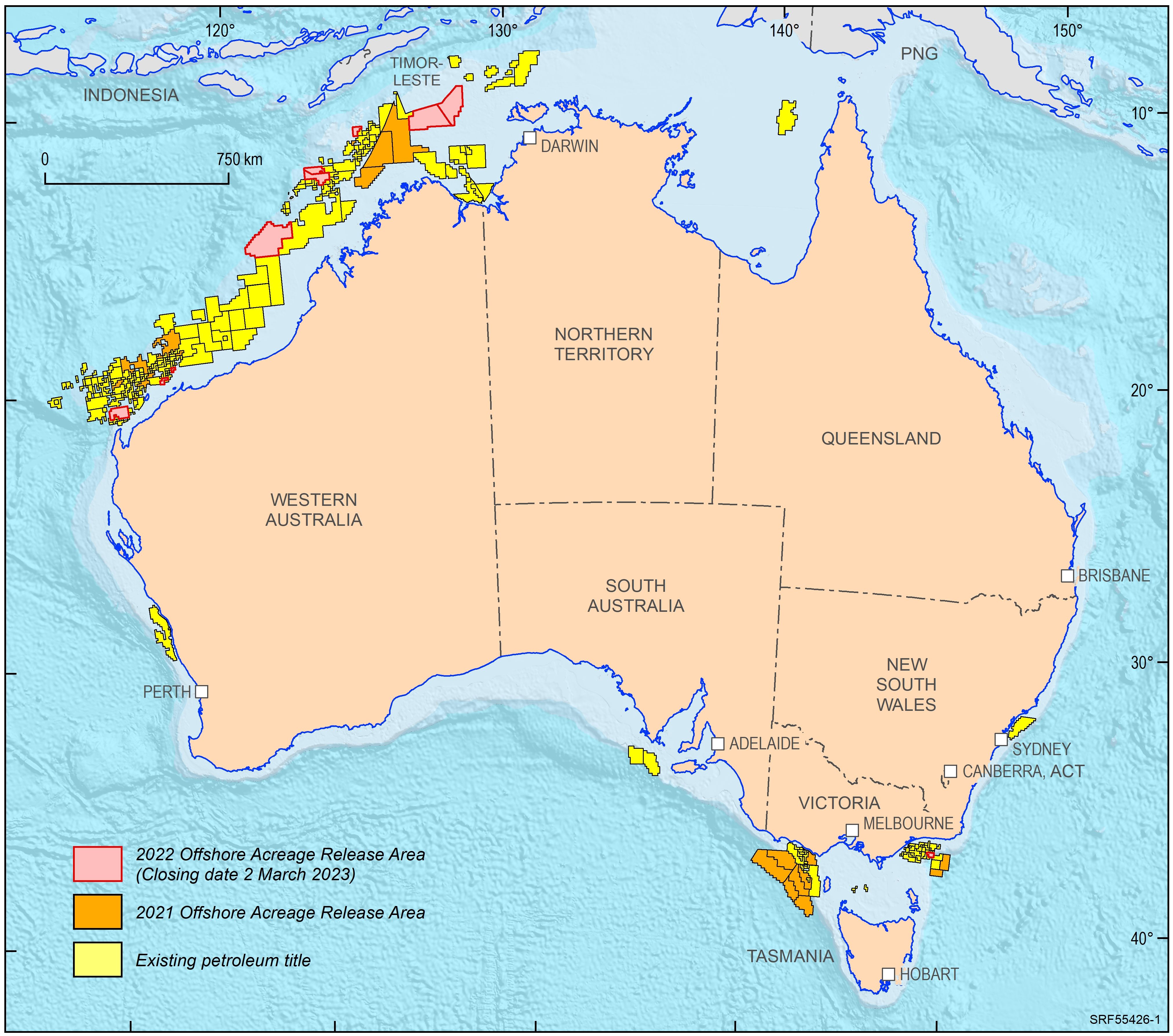
<div>In 2022, the Australian Government released ten offshore petroleum exploration areas. They are located in the Bonaparte Basin, Browse Basin, Northern Carnarvon Basin and Gippsland Basin. The areas highlight that producing provinces rather than data-poor regions are the preferred targets for exploration activities. In addition, the transition to low carbon energy resources, including opportunities for carbon capture and storage, has seen a diversification of energy companies’ portfolios. The Australian Government is supportive of the upstream energy industry, with natural gas seen as an important enabling energy resource commodity that supports the expansion of low emission technologies and related infrastructure. Most of the areas being offered for exploration in 2022 are likely to generate extra volumes of natural gas, both for domestic markets as well as securing feedstock for existing LNG export projects for the longer term. </div><div>Consistent with the approach of recent releases, only one period for work program bidding has been scheduled. The closing date for all bid submissions is 2 March 2023. </div><div>Geoscience Australia provides pre-competitive data and petroleum geological information in support of industry activities. Its petroleum geological studies aim to improve the understanding of the evolution of hydrocarbon-bearing basins at a regional scale and include a review of source rock and fluid occurrences, their geochemical characteristics, and petroleum systems modelling. Most recent examples include a sedimentological/stratigraphic study that investigates the depositional history of the southern Bonaparte Basin during the late Permian to Early Triassic evaluating the controls on reservoir facies development. A regional petroleum geological study of the Otway Basin, with a focus on the deeper water area and utilising newly industry acquired regional seismic data, provides new insights into the hydrocarbon prospectivity of this largely underexplored offshore part of the basin. Latest results of these studies were presented at this year’s APPEA conference. Large seismic and well data sets, submitted under the Offshore Petroleum and Greenhouse Gas Storage Act 2006 (OPGSSA) are made available through the National Offshore Petroleum Information Management System (NOPIMS). Additional data and petroleum related information can be accessed through Geoscience Australia’s data repository</div><div><br></div>
-
<div>The mineral potential toolkit (aka minpot-toolkit) provides tools to facilitate mineral potential analysis, from spatial associations to feature engineering and fully integrated mineral potential mapping.</div>
-
<div>The study utilised Geoscience Australia’s vast data collection of mineral occurrences to identify the range of historical discoveries within the Officer-Musgrave, Darling-Curnamona - Delameian and Barkly - Isa - Georgetown Deep Dive areas. A literature review shed light on exploration discovery methods, commodity grades, exploration histories and deposit types. Many critical mineral occurrences were overlooked or ignored in the past, as the commodity discovered was not of interest or value at the time, or grades were regarded as sub-economic. However, with modern methods of mining, ore treatment techniques and increased demand, reassessment could now provide new opportunities.</div>
-
<div>The Canning Basin is a prospective hydrocarbon frontier basin and is unusual for having limited offshore seismic and well data in comparison with its onshore extent. In this study, seismic mapping was conducted to better resolve the continuity of 13 key stratigraphic units from onshore to offshore to delineate prospective offshore hydrocarbon-bearing units, and better understand the distribution of mafic igneous units that can compartmentalise migration pathways and influence heat flow. The offshore Canning Basin strata are poorly constrained in six wells with limited seismic coverage; hence data availability was bolstered by integrating data from the onshore portion of the basin and adjacent basins into a single 3D seismic stratigraphic model. This model integrates over 10 000 km of historical 2D seismic data and 23 exploration wells to allow mapping of key stratal surfaces. Mapped seismic horizons were used to construct isochores and regional cross-sections. Seven of the 13 units were mapped offshore for the first time, revealing that the onshore and offshore stratigraphy are similar, albeit with some minor differences, and mafic igneous units are more interconnected than previously documented whereby they may constitute a mafic magmatic province. These basin-scale maps provide a framework for future research and resource exploration in the Canning Basin. To better understand the basin’s geological evolution, tectonic history and petroleum prospectivity, additional well data are needed in the offshore Canning Basin where Ordovician strata have yet to be sampled.</div><div><br></div><div>C. T. G. Yule, J. Daniell, D. S. Edwards, N. Rollet & E. M. Roberts (2023). Reconciling the onshore/offshore stratigraphy of the Canning Basin and implications for petroleum prospectivity, Australian Journal of Earth Sciences, DOI: 10.1080/08120099.2023.2194945</div> Appeared in Australian Journal of Earth Sciences Pages 691-715, Volume 70, 2023 - Issue 5.
-
<div>Convergent margins are a hallmark feature of modern style plate tectonics. One expression of their operation is metallogenesis, which therefore may yield important insights into secular changes in styles of convergence and subduction. A global comparison of metallogenesis along convergent margins of over 20 well-endowed provinces indicates a consistent and systematic progression of mineral deposit types. We term this progression the convergent margin metallogenic cycle (CMMC). </div><div> This CMMC mirrors convergent margin evolution. Each metallogenic cycle begins with the formation of porphyry copper deposits and/or volcanic-hosted massive sulphide deposits, associated with arc construction and back arc basin formation, respectively. When the convergent margin transitions into contraction/orogenesis due to processes such as accretion, flattening of subduction, or continent-continent collision, mineral deposits that form include orogenic gold and structurally hosted base metal deposits. Post-contractional extension is marked by the formation of intrusion related rare metal (tin, tungsten, molybdenum) and gold deposits, pegmatites, and alkaline porphyry copper deposits, closing the CMMC. </div><div> Our analysis of the metallogenic record reveals that prior to ~3 Ga, metallogenesis is episodic and non-systematic, with CMMCs not recognised. From the mid- to late Mesoarchean onwards, CMMCs are observed in all provinces analysed, and display systematic trends through time: the Meso- to Neoarchean metallogenic provinces are characterized by a single metallogenic cycle, whereas in the Paleo- to Mesoproterozoic provinces, both single and multiple metallogenic cycles occur. From the middle Neoproterozoic onwards multiple metallogenic cycles are the rule. This evolution is accompanied by an increase in the duration of metallogenesis, ranging from ~100 to 180 million years in the Meso- to Neoarchean and 220 to more than 400 million years since the late Proterozoic. </div><div> We interpret these trends to reflect secular changes in tectonic processes and Earth evolution. The emergence of CMMCs from ~3 Ga provides independent evidence for the operation of some early form of subduction since this time. The fact that CMMCs are recognized in all provinces of mid-Meso- to Neoarchean age suggests that subduction was the common <em>modus operandi</em> rather than an exception. The first appearance of multiple metallogenic cycles in the Paleoproterozoic may reflect the strengthening of cratonic margins by tectonothermal maturation since formation in the Archean. Long-lived metallogenesis and multiple metallogenic cycles in the Neoproterozoic and Phanerozoic are linked to deep-slab break-off, or modern, subduction in which the internal strength of the subducting slab allows maintenance of slab coherency. </div><div> This Abstract was submitted/presented to the 2023 6th International Archean Symposium (6IAS) 25 - 27 July (https://6ias.org/)
-
<div>Raster datasets of inferred magnesium number for the bulk lithospheric mantle across the Australian continent. The magnesium number is an elemental ratio, defined by Mg / (Mg + Fe), which correlates to the relative enrichment or depletion in incompatible elements. Oxide concentrations are inferred in from thermo-chemical inverse modelling of Rayleigh phase velocities, surface heat flow, geoid anomalies, and topography. The magnesium number rasters summarise the results of a Markov-chain Monte Carlo sampling of the posterior model space from an ensemble of plausible candidate models. Model release 'FR23' is developed using primary-mode Rayleigh phase velocity grids adapted from Fishwick & Rawlinson (2012; "3-D structure of the Australian lithosphere from evolving seismic datasets"). Model release 'KY22' is developed using the primary-mode Rayleigh phase velocity grids of Yoshizawa (2014; "Radially anisotropic 3-D shear wave structure of the Australian lithosphere and asthenosphere from multi-mode surface waves"). All models are products of the Exploring for the Future program.</div>
-
<div>Two new programs at Geoscience Australia are providing trusted, high-quality science to support decision making and the Australian resources industry. </div><div> </div><div>The Trusted Environmental and Geological Information program will provide baseline pre-competitive data in the Cooper, Adavale, north Bowen and Galilee basin regions. A repository of information is being developed in collaboration with CSIRO, including new geological and environmental assessments, to accelerate development in the sectors of petroleum, mineral, hydrogen and carbon capture and storage, while simultaneously providing opportunities to understand the potential hazards, risk and impacts of these resources being developed. </div><div> </div><div>The Data Driven Discoveries program is combining new and old data to better understand the under-explored Adavale Basin in central-western Queensland. The program will undertake chemical composition analyses to support the correlation of geological layers, collate and reprocess historical seismic data, acquire new seismic reflection data, and undertake stratigraphic research drilling to provide a more detailed understanding of basin architecture and the resource potential of the Adavale Basin. </div><div> </div><div>An overview of the Trusted Environmental and Geological Information and Data Driven Discoveries programs will be provided, including initial results and planned acquisition. This will show how these complementary programs will contribute to streamlined regulation and approval processes, the low emissions agenda, and responsible resource development in key basin regions across Australia.</div> This Abstract was submitted/presented to the 2022 Petroleum Exploration Society of Australia (PESA) QLD Symposium 9 September (https://pesa.com.au/events/pesa-qld-2022-symposium/)